philip s rgs modern school atlas philip s maps
Philip's RGS Modern School Atlas - Philip's Maps
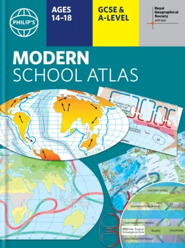
- Britain''s best-selling school atlas - now in its 101st edition- Recommended for Key Stage 4, GCSE and A-Level in England and Wales (Scottish National Qualifications/Highers) and international schools- Fully updated to reflect the latest changes in the curriculum- Published in association with the Royal Geographical Society- Combines superb digital maps of Britain and the world with up-to-date thematic maps - Country-by-country statistics on population, land use, trade, tourism, energy, wealth and much more - World Themes Section - from volcanoes and earthquakes to population trends, languages and religions, all the key aspects and statistics of geography are explored and explained- Plus a special section on how satellite imagery is used to interpret global, environmental and urban patterns of change Britain''s best-selling secondary school atlas, now in its 101st Edition. The contents are divided into colour-coded sections for rapid reference. The physical maps of the United Kingdom and Ireland are accompanied by thematic maps on numerous key social and economic themes. World topographical maps, with thematic maps on topics such as climate, population and economics, are followed by 30 pages of World thematic maps.Completing the atlas is a section of World social and economic statistics, and an index with letter-figure ... Unknown localization key: "more"
Objev podobné jako Philip's RGS Modern School Atlas - Philip's Maps
Philip's RGS Essential School Atlas - Philip's Maps
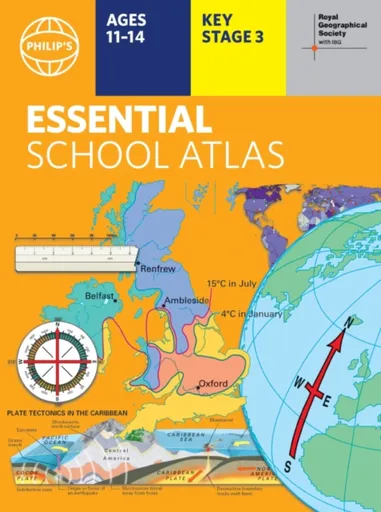
"An excellent world atlas. Very illuminating, good colours, clear texts...good glossary and, last but not least, up-to-date." - customer review- The ideal school atlas for Key Stage 3 pupils and Scotland''s National Qualifications, 11-14 years old- All updated for 2024 specifically to meet curriculum needs- Specially focused 16-page UK and Ireland section- Comprehensive 62-page world section includes thematic maps on the environment, climate change, people, quality of life, and energy- Published in association with the Royal Geographical SocietyPhilip''s RGS Essential School Atlas has been specially created for lower-secondary geography students (11-14 year olds). The maps have been carefully designed to be uncluttered and easy to read, containing specially selected place names and detail. A clear set of symbols and scale information accompanies every map, with a useful introductory section covering basic atlas skills, including aerial photographs and satellite images to further explain particular features on the maps. Latitude and longitude co-ordinates are included in the index, alongside figure-letter references. Fully up-to-date, the atlas includes detailed regional maps, charts and satellite images of Europe, Italy, the Middle East, China, Japan, Kenya, USA, Brazil, and the Arctic and Antarctica. It also focuses on areas of special interest for students of geography, such ... Unknown localization key: "more"
Objev podobné jako Philip's RGS Essential School Atlas - Philip's Maps

Philip's RGS Essential School Atlas - Philip's Maps
"An excellent world atlas. Very illuminating, good colours, clear texts...good glossary and, last but not least, up-to-date." - customer review- The ideal school atlas for Key Stage 3 pupils and Scotland''s National Qualifications, 11-14 years old- All updated for 2024 specifically to meet curriculum needs- Specially focused 16-page UK and Ireland section- Comprehensive 62-page world section includes thematic maps on the environment, climate change, people, quality of life, and energy- Published in association with the Royal Geographical SocietyPhilip''s RGS Essential School Atlas has been specially created for lower-secondary geography students (11-14 year olds). The maps have been carefully designed to be uncluttered and easy to read, containing specially selected place names and detail. A clear set of symbols and scale information accompanies every map, with a useful introductory section covering basic atlas skills, including aerial photographs and satellite images to further explain particular features on the maps. Latitude and longitude co-ordinates are included in the index, alongside figure-letter references. Fully up-to-date, the atlas includes detailed regional maps, charts and satellite images of Europe, Italy, the Middle East, China, Japan, Kenya, USA, Brazil, and the Arctic and Antarctica. It also focuses on areas of special interest for students of geography, such ... Unknown localization key: "more"
Objev podobné jako Philip's RGS Essential School Atlas - Philip's Maps
Podívejte se také
první díl série Bailey School Kids
věšák na boty Wenko Atlas
povlečení atlas grádl zelené
povlak na polštář 70x90 cm atlas grádl
povlečení atlas grádl pro ložnici
povlečení atlas grádl zelené 140x200 cm
luxusní bavlněné povlečení atlas grádl
povlak na přikrývku 140x200 z atlas grádlu
povlečení z 100% bavlny atlas grádl
povlečení atlas grádl starorůžová
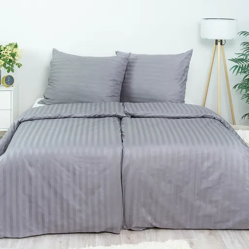
povlečení atlas grádl světle šedá
povlečení atlas grádl pro dospělé
tmavě šedé atlas grádl povlečení
povlečení atlas grádl 140x200 cm
100% bavlna povlečení atlas grádl
péče o povlečení atlas grádl
Philip's RGS Junior School Atlas - Philip's Maps
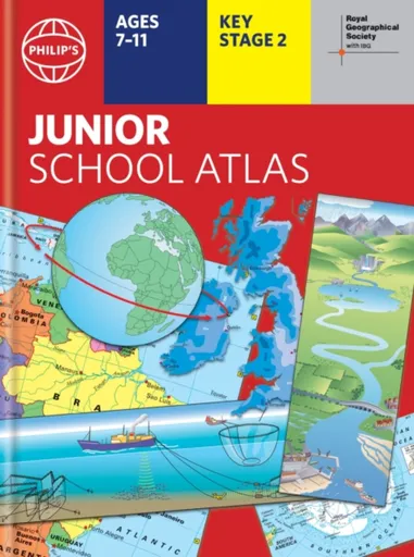
The 12th edition of the market-leading atlas for primary school pupils, Philip''s RGS Junior School Atlas has been fully revised and updated with all the latest facts and curriculum requirements.- The essential atlas for primary schools with clear and easy-to-follow maps and diagrams - updated for 2024/2025- Published in association with the Royal Geographical Society- Recommended for Key Stage 2 of the National Curriculum - and all 7-11 year olds - An excellent introduction to mapping concepts such as scale, direction, symbols, longitude and latitude- 22-page Britain and Ireland section with clear thematic charts, diagrams and large-scale regional maps- 22-page section on The World, with political maps - and thematic treatment of key themes, from volcanoes and earthquakes to transport and tourism- Continents section with physical and political maps- Easy-to-follow map references and 1,000-place indexThe introductory section describes the meaning of scale, how to measure distances using the maps, and explains the symbols on the maps.The following section is devoted to the United Kingdom and Ireland. Thematic maps cover topics such as mountains and rivers, climate and weather, population and cities, farming and fishing, industry and energy, transport, tourism and conservation. The rest of the atlas is made up of ... Unknown localization key: "more"
Objev podobné jako Philip's RGS Junior School Atlas - Philip's Maps

Philip's RGS Modern School Atlas
Britain's best-selling school atlas - now in its 101st edition Recommended for Key Stage 4, GCSE and A-Level in England and Wales (Scottish National Qualifications/Highers) and international schools Fully updated to reflect the latest changes in the curriculum Published in association with the Royal Geographical Society Combines superb digital maps of Britain and the world with up-to-date thematic maps Country-by-country statistics on population, land use, trade, tourism, energy, wealth and much more - World Themes Section - from volcanoes and earthquakes to population trends, languages and religions, all the key aspects and statistics of geography are explored and explained- Plus a special section on how satellite imagery is used to interpret global, environmental and urban patterns of change Britain's best-selling secondary school atlas, now in its 101st Edition. The contents are divided into colour-coded sections for rapid reference. The physical maps of the United Kingdom and Ireland are accompanied by thematic maps on numerous key social and economic themes. World topographical maps, with thematic maps on topics such as climate, population and economics, are followed by 30 pages of World thematic maps.Completing the atlas is a section of World social and economic statistics, and an index with letter-figure grid references ... Unknown localization key: "more"
Objev podobné jako Philip's RGS Modern School Atlas
Philip's RGS Infant School Atlas - David Wright, Philip's Maps, Rachel Noonan
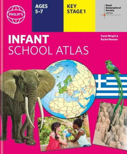
Written for 5 to 7 year-old this atlas is ideal for teaching Key Stage 1, helping to cover geography, history, science, citizenship and literacy requirements- Written by experts Professor David Wright and Rachel Noonan- Published in association with the Royal Geographical Society- 50 pages of clear, child-friendly maps showing our world today- Countries of the world brought to life with flags, illustrations and photos- Bold text, simple words and short sentences to encourage reading skills- Starts with the Earth as a Planet then zooms into each of the world''s regions with maps and illustrations- Numbered balloons on each map link to photos of a real placeFully revised and updated, the atlas is for children aged 5-7 in the early stages of reading, with simple text to explain what is happening on the maps and illustrations - all compatible with National Curriculum Key Stage 1.Clear, child-friendly maps are combined with vibrant photographs and facts about the world. Guidance is given at the beginning of the atlas on how to use the maps, encouraging the early development of map skills. Each colourful spread is illustrated with photographs and packed with fact boxes, curiosities, flags, stamps and simple quiz questions. Philip''s RGS Infant ... Unknown localization key: "more"
Objev podobné jako Philip's RGS Infant School Atlas - David Wright, Philip's Maps, Rachel Noonan
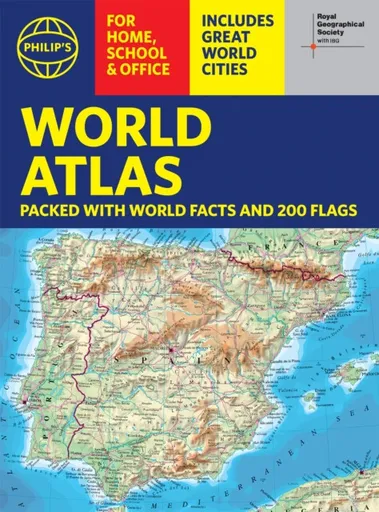
Philip's RGS World Atlas (A4) - Philip's Maps
Thousands of global facts at your fingertips with the best value quick-reference World Atlas on the market. Both physical and political geography is clearly illustrated alongside the great cities of our planet.The highest peak? The deepest ocean trench? The wettest, driest, longest, largest - we list the world''s fascinating extremes. Crammed with practical information like a Distance Chart for World Cities, World Time Zones, over 200 State Flags and the top 100 most populous countries, we include around 15,000 places indexed for easy checking. Whether for the pub quiz, travel planning or school reference, this great value handy world atlas is crammed with everything you need to know.Alongside the topography and physical attributes of the earth we also show political boundaries and the great global cities, including transport hubs and places of interest from mosques to temples, palaces to zoos and shopping centres to tourist information centres.Features include: * 200 Flags of the world''s major states and territories* 21 City centre maps: transport (road, rail, trams, light railways, bus and railway stations) and places of interest including religious buildings (churches, abbeys, cathedrals, synagogues, shrines, temples, mosques), museums, galleries, theatres, palaces, castles, parks, gardens, zoos, shopping centres, hospitals, Tourist Centres.* World ... Unknown localization key: "more"
Objev podobné jako Philip's RGS World Atlas (A4) - Philip's Maps
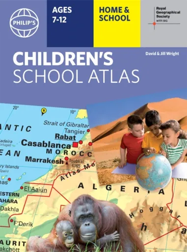
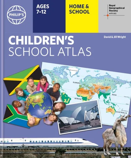
Philip's RGS Children's School Atlas - David Wright, Jill Wright
"This is such a great book for primary school age children and a little beyond for finding out about the world, its countries and people" Amazon customer review- Philip''s atlas, designed specially to use at home and at school with guidance for parents and teachers- Clear maps and fascinating facts bring geography to life for readers aged 7-12- Published by Philip''s the UK''s leading school atlas publisher, in association with the Royal Geographical Society- Quizzes, activity ideas and puzzles to make learning fun- Past winner of the Geographical Association''s award for making a significant contribution to geographyThe atlas is organized spread by spread in the classic sequence: first Europe, then its land neighbour Asia, followed by Africa, Australia and Oceania, North America and South America.Illustrated with captivating full-colour photographs and packed with fact boxes, curiosities, flags, stamps and quiz questions, Philip''s RGS Children''s Atlas is both fun to use and easy to understand.Now in its 16th edition, Philip''s RGS Children''s Atlas is a past winner of the Geographical Association''s award for making a significant contribution to geography. The atlas was judged "an excellent ''all round'' children''s atlas with simple yet well-designed maps, well-illustrated with colour photographs. It links places to ... Unknown localization key: "more"
Objev podobné jako Philip's RGS Children's School Atlas - David Wright, Jill Wright
Philip's RGS Children's School Atlas - David Wright, Jill Wright
"This is such a great book for primary school age children and a little beyond for finding out about the world, its countries and people" customer review- Philip''s atlas, designed specially to use at home and at school with guidance for parents and teachers- Clear maps and fascinating facts bring geography to life for readers aged 7-12- Published by Philip''s in association with the Royal Geographical Society- Quizzes, activity ideas and puzzles to make learning fun- Past winner of the Geographical Association''s award for making a significant contribution to geographyThe atlas is organized spread by spread in the classic sequence: first Europe, then its land neighbour Asia, followed by Africa, Australia and Oceania, North America and South America. Illustrated with captivating full-colour photographs and packed with fact boxes, curiosities, flags, stamps and quiz questions, Philip''s RGS Children''s Atlas is both fun to use and easy to understand.Now in its 17th edition, Philip''s RGS Children''s Atlas is a past winner of the Geographical Association''s award for making a significant contribution to geography. The atlas was judged "an excellent ''all round'' children''s atlas with simple yet well-designed maps, well-illustrated with colour photographs. It links places to issues, events and real people, giving ... Unknown localization key: "more"
Objev podobné jako Philip's RGS Children's School Atlas - David Wright, Jill Wright

Philip's RGS Children's School Atlas - David Wright, Jill Wright
"This is such a great book for primary school age children and a little beyond for finding out about the world, its countries and people" customer review- Philip''s atlas, designed to use at home and at school with guidance for parents and teachers- Clear maps and fascinating facts bring geography to life for readers aged 7-12- Published by Philip''s in association with the Royal Geographical Society- Quizzes, activity ideas and puzzles to make learning fun- Past winner of the Geographical Association''s award for making a significant contribution to geographyThe atlas is organized spread by spread in the classic sequence: first Europe, then its land neighbour Asia, followed by Africa, Australia and Oceania, North America and South America. Illustrated with captivating full-colour photographs and packed with fact boxes, curiosities, flags, stamps and quiz questions, Philip''s RGS Children''s Atlas is both fun to use and easy to understand.Now in its 17th edition, Philip''s RGS Children''s Atlas is a past winner of the Geographical Association''s award for making a significant contribution to geography. The atlas was judged "an excellent ''all round'' children''s atlas with simple yet well-designed maps, well-illustrated with colour photographs. It links places to issues, events and real people, giving a ... Unknown localization key: "more"
Objev podobné jako Philip's RGS Children's School Atlas - David Wright, Jill Wright
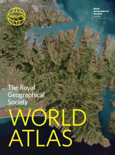
Philip's RGS World Atlas - Philip's Maps
"An excellent world atlas. Very illuminating, good colours, clear texts...good glossary and, last but not least, up-to-date". Amazon customer review· The perfect world atlas for work, study or leisure· Great value for money· 96 pages of authoritative world maps, physical and political· 70 city maps in the fascinating World Cities section, with full-page satellite images for 10 great cities· Over 35,000 place name indexAll this and a special 32-page introductory section - ''The World in Focus'' - covers key geographical themes such as the Earth''s position in the Solar System, the structure of the Earth, climate and weather, the environment, population, resources, economics and international organizations. Vital information on topics covered in geography, humanities and economics courses.The information-packed World Atlas from Philip''s, published in association with the Royal Geographical Society has been fully updated for this new, 2021 edition
Objev podobné jako Philip's RGS World Atlas - Philip's Maps

Philip's Caribbean Atlas for Secondary Schools - Philip's Maps
A new edition of the market-leading atlas for CXC Geography students, Philip''s Caribbean Atlas for Secondary Schools provides extensive coverage of the Caribbean area, together with a comprehensive selection of world and regional maps. The atlas is arranged in three sections for ease of use, with each page colour-coded for rapid reference. The first section is devoted to a detailed coverage of the Caribbean region in 48 pages, and includes maps of every island plus Belize and Guyana, as well as topographical, land use, tourism and mining maps.The second section is made up of 72 pages of World topographical maps, incorporating continental thematic maps on topics such as population, climate and biomes, followed by 32 pages of World thematic maps. This new 8th edition features updated mapping of all Caribbean islands, as well as the latest statistics. The World map section contains additional coverage of Brazil, the Americas and Asia, while the World thematic section includes maps on volcanoes, El Niño, tourism, energy, minerals, industry, trade and international organizations.Completing the atlas is a section of CXC study maps covering topics such as farming, soil conservation, economics, tourism and urban land use. Features regional studies of Mauritius, UK, Canada, USA and ... Unknown localization key: "more"
Objev podobné jako Philip's Caribbean Atlas for Secondary Schools - Philip's Maps
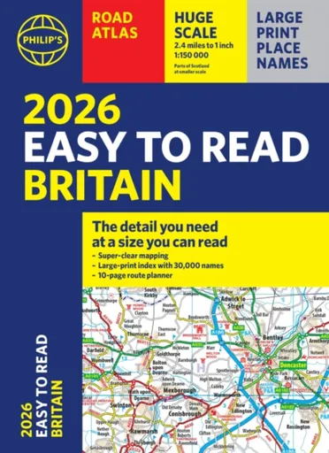
2026 Philip's Easy to Read Road Atlas of Britain - Philip's Maps
"The detail you need at a size you can read". The latest 2026 Philip''s Easy to Read Road Atlas of Britain from the best-selling Road Atlas range has over 350 pages packed with exceptionally clear mapping and everything you need for exploring Britain. Now available as a practical paperback, it will enhance any trip.· Clear maps packed with extra details for a better journey· Huge 1:150,000 scale (approx 2.4 miles to 1 inch)· Large print place names· Large print index· Super-clear 10-page route planner to create the best journeys· Thousands of attractions clearly mapped, including castles, theme parks, gardens, zoos and more.· London''s expanded ULEZ clearly shown on approach mapping· Over 100,000 copies of the Philip''s Easy Read Road Atlases of Britain sold since launch in 2020.At last, a road atlas that everyone can read easily, in or out of the car, no matter what the conditions. With up-to-date mapping technology, your travels have never been easier to plan. This edition contains a wealth of useful information, including tourist attractions, to ensure the best possible journey. Whether it''s dark, or if you just can''t find your glasses, the 2026 Philip''s Easy to Read Road Atlas of Britain is the ultimate ... Unknown localization key: "more"
Objev podobné jako 2026 Philip's Easy to Read Road Atlas of Britain - Philip's Maps
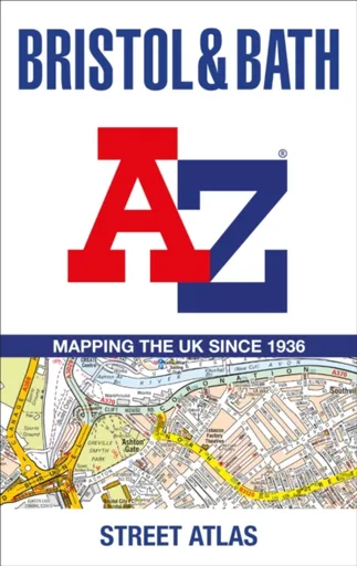
Bristol and Bath A-Z Street Atlas - A-Z Maps
Navigate your way around Bristol and Bath with this detailed and easy-to-use A-Z Street Atlas.Printed in full-colour, paperback format, this atlas contains 104 pages of continuous street mapping. More than 12,800 streets indexed. Large scale 6.25 inches to 1 mile map.Areas covered include: Avonmouth, Bradley Stoke, Filton, Keynsham, Kingswood, Mangotsfield, Portishead, Yate, Frampton Cotterell, Chipping Sodbury, Oldland, Swainswick, Batheaston, University of Bath, Combe Down, Bath Spa University, Saltford, Whitchurch, Bedminster, Long Ashton, Easton-in-Gordano, Cribbs Causeway.Also included are large scale city centre maps of both Bristol and Bath and a postcode map of the atlas area.Postcode districts, one-way streets and safety camera locations with their maximum speed are featured on the street mapping.A comprehensive index lists streets, selected flats, walkways and places of interest, place, area and station names. Additional healthcare (hospitals, walk-in centres and hospices) and transport connections are indexed as well.
Objev podobné jako Bristol and Bath A-Z Street Atlas - A-Z Maps
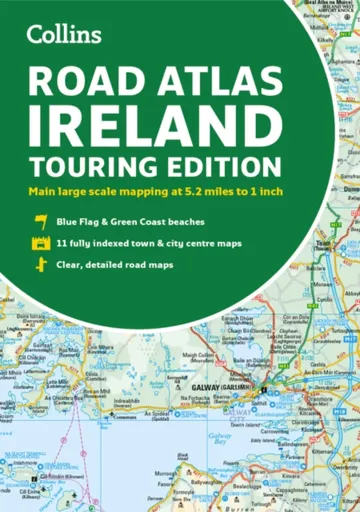
Road Atlas Ireland - Collins Maps
Explore Ireland with this accurate and fully updated road atlas.This road atlas is at A4 size, covering the whole of Ireland and features clear and detailed Collins colour mapping at a scale of 5.2 miles to 1 inch. Perfect for both residents and visitorstouring Ireland.This revised edition includes:Places of tourist interestContact information for Tourist Information Centres with grid references to the mappingFully indexed street maps of 11 cities and towns – Dublin, Belfast, Cork, Limerick, Waterford,Londonderry (Derry), Galway, Bangor, Dun Laoghaire, Drogheda and KillarneyBlue Flag & Green Coast beachesFerry and airport information; Distance chart; Distances marked on the roads in miles and kilometresRoute planning map of the whole of Ireland at 15.8 miles to 1 inchAdministrative map of Irish counties and districts.
Objev podobné jako Road Atlas Ireland - Collins Maps
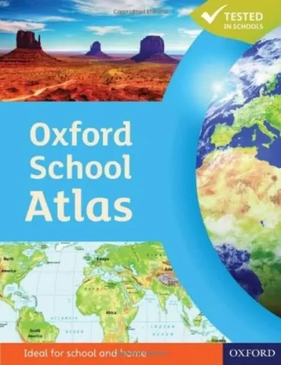
Oxford School Atlas - Wiegand Patrick
The Oxford School Atlas includes country data and easy-to-read colourful mapping, presented in an accessible visual layout based on research into how students use maps. The atlas covers key curriculum themes such as earthquakes and volcanoes, climate, economic activity, and development. It includes comprehensive coverage of the British Isles, and case studies of Italy, Kenya, Brazil, Japan, China, California, the Indian Ocean tsunami, Hurricane Katrina, and Antarctica.
Objev podobné jako Oxford School Atlas - Wiegand Patrick
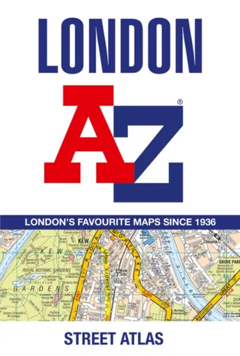
London A-Z Street Atlas - A-Z Maps
Navigate your way around London with this detailed, easy-to-use and up-to-date A-Z Street Atlas.First published in 1936, this iconic atlas is a trusted means of finding your way around the capital city.The main mapping extends beyond Central London from Heathrow Airport to Chingford at a scale of 2.88 inches to 1 mile (4.55 cm to 1 km), featuring postcode districts, one-way streets, the Congestion Charging Zone and Low Emission Zone.The large-scale street map of Central London – at a scale of 5.75 inches to 1 mile – cover Regent’s Park and Shoreditch, Chelsea and Vauxhall, Hyde Park and Bermondsey.A comprehensive index lists streets, selected flats, walkways and places of interest, place, area and junction names. Additional healthcare (hospitals, walk-in centres and hospices) and transport connections (National Rail, London Tramlink, Docklands Light Railway, London Underground and Overground stations, and River Bus pier) are indexed as well.Also included are:• Overview map of the Congestion Charging Zone, Ultra Low Emission and Low Emission Zones• West End Theatre map• London Connections rail services map
Objev podobné jako London A-Z Street Atlas - A-Z Maps
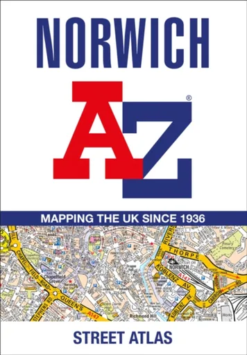
Norwich A-Z Street Atlas - A-Z Maps
Navigate your way around Norwich with this detailed and easy-to-use A-Z Street Atlas.Printed in full-colour, paperback format, this atlas contains 42 pages of continuous street mapping. More than 4,500 streets indexed. Large scale 4 inches to 1 mile map.Areas covered include :Blofield, Blofield Heath, Brundall, Cringleford, Hethersett, Norwich Airport,Poringland, Spixworth, Sprowston, Taverham, Wroxham, Wymondham.In addition, there is an inset map of Horsford and a large scale city centre map of Norwich.Postcode districts, one-way streets and safety camera locations with their maximum speed are featured on the street mapping.A comprehensive index lists streets, selected flats, walkways and places of interest, place, area and station names. Additional healthcare (hospitals, walk-in centres and hospices) and transport connections are indexed as well.
Objev podobné jako Norwich A-Z Street Atlas - A-Z Maps
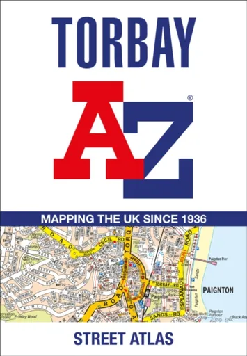
Torbay A-Z Street Atlas - A-Z Maps
Navigate your way around Torbay with this detailed and easy-to-use A-Z Street Atlas.Printed in full-colour, paperback format, this atlas contains 38 pages of continuous street mapping. More than 5,100 streets indexed. Large scale 4 inches to 1 mile map.Areas covered include: Brixham, Paignton, Torquay, Kingskerswell, Newton Abbot, Bovey Tracey, Teignmouth, Dawlish, Ashburton, Buckfastleigh, Totnes, Kingsbridge, Salcombe, Dartmouth.In addition, there are insets of: Bishopsteignton, Ipplepen, Stoke Gabriel and a large scale town centre map of Dartmouth.Postcode districts, one-way streets, Park and Ride sites, safety camera locations with their maximum speed and Dartmoor National Park boundary are featured on the mapping.The Places of Interest Guide is both informative and helpful with information about:Tourist Information CentresBoat tripsSelected places of interestThe English RivieraA comprehensive index lists streets, selected flats, walkways and places of interest, place, area and station names. Additional healthcare (hospitals, walk-in centres and hospices) and transport connections are indexed as well.
Objev podobné jako Torbay A-Z Street Atlas - A-Z Maps
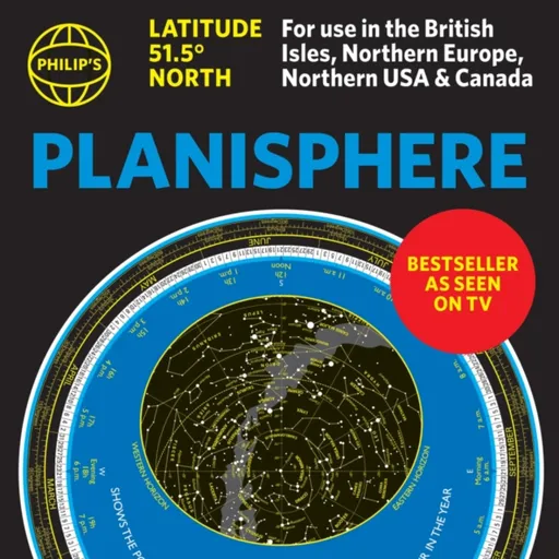
Philip's Planisphere (Latitude 51.5 North) - Philip's Maps
The first thing that every stargazer needs - an hour-by-hour and night-by-night moveable map of the stars ''A really useful bit of kit...a map of the night sky for any time of the year'' Mark Thompson, TV Astronomer on BBC Stargazing Live- Just turn the disc and ''dial up'' tonight''s night sky- Bestselling and accurate sky map for every hour of every night 24/7/365- Simple and fun to use for beginners - and an essential tool for experienced astronomers- All the stars and constellations down to magnitude 5 (visible with the naked eye)- Planet Tracker for the major visible planets - Full instructions and hints on exploring the skies by season - Suitable for UK, Ireland, Northern Europe, Canada and Northern USA (51.5N plus or minus 10 degrees)Philip''s have created a bestselling, practical, hour-by-hour tracker of the stars and constellations. Turn the oval panel to tonight''s date and time - and reveal the whole sky star by star visible from where you are. The map shows stars down to magnitude 5, plus several important deep-sky objects such as the Pleiades, the Andromeda Galaxy (M31) and the Orion Nebula (M42) The Planisphere is based at 51.5 degrees North. So it''s perfect ... Unknown localization key: "more"
Objev podobné jako Philip's Planisphere (Latitude 51.5 North) - Philip's Maps
The Making of the Modern Philippines - Bowring Philip
"Well-researched... a welcome guide." The Spectator"Reliable and lucid." History TodayWith a fractured geography and complex identity, The Philippines is an eclectic and unique mix of culture, environment, people and politics. Known mostly for natural disasters, migrant labour and dictatorial presidents, in this book Philip Bowing shows how it is much, much more. Deftly navigating the history of this populous island republic, The Making of the Modern Philippines traces its history to define and explain its position in the modern world. Looking past the headlines of volcanoes, earthquakes and violence, it asks why has the Filipino economy lagged behind its neighbours, explores the importance of its location in geopolitics, and investigates how its deep-rooted Catholicism clashes with the Islamic consciousness of the region in which it sits. Taking the history of the Philippines from its pre-colonial era, through its Spanish and American occupations and up to the modern day, it unravels the complex politics, culture, peoples and economy of this rich and unique nation. Engaging with challenges the Filipino people face today such as federalism, revolution, Mindanao, the diaspora, capitalism and relations with China, it rediscovers the struggles, culture and history of its past to understand the present.
Objev podobné jako The Making of the Modern Philippines - Bowring Philip
Stanex Povlečení atlas grádl tmavě šedá, 140 x 200 cm, 70 x 90 cm
Povlečení z atlas grádlu je vyrobeno ze 100% bavlny a nabízí pohodlí a hebkost. Tmavě šedý odstín a struktura proužků dodávají elegantní vzhled. Souprava obsahuje povlak na polštář 70x90 cm a povlak na přikrývku 140x200 cm.
- Vyrobeno ze 100% kvalitní bavlny pro mimořádnou hebkost
- Elegantní tmavě šedý odstín a struktura 2,5 cm proužků
- Snadná údržba – perte naruby bez bělidel
Objev podobné jako Stanex Povlečení atlas grádl tmavě šedá, 140 x 200 cm, 70 x 90 cm
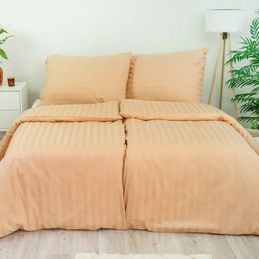
Stanex Povlečení atlas grádl béžová, 140 x 200 cm, 70 x 90 cm
Povlečení z atlas grádlu je vyrobeno z 100% bavlny a nabízí pohodlí a hebkost. Béžový odstín a struktura proužků dodávají elegantní vzhled. Souprava obsahuje povlak na přikrývku 140x200 cm a povlak na polštář 70x90 cm.
- Vyrobeno ze 100% kvalitní bavlny pro mimořádnou hebkost.
- Elegantní design s 2,5 cm proužky a noblesním béžovým odstínem.
- Snadná údržba – perte naruby bez bělidel a chemických čistidel.
- Kompletní souprava obsahuje povlak na přikrývku i polštář.
Objev podobné jako Stanex Povlečení atlas grádl béžová, 140 x 200 cm, 70 x 90 cm

Stanex Povlečení atlas grádl světle šedá, 140 x 200 cm, 70 x 90 cm
Povlečení z atlas grádlu je vyrobeno z 100% bavlny a nabízí pohodlí a hebkost. Světle šedý odstín a struktura proužků dodávají elegantní vzhled. Souprava obsahuje povlak na přikrývku 140x200 cm a povlak na polštář 70x90 cm.
- Vyrobeno ze 100% kvalitní bavlny pro mimořádnou hebkost.
- Elegantní design s 2,5 cm proužky a světle šedým odstínem.
- Snadná údržba – doporučeno prát naruby bez agresivní chemie.
- Kompletní souprava obsahuje povlak na přikrývku i polštář.
Objev podobné jako Stanex Povlečení atlas grádl světle šedá, 140 x 200 cm, 70 x 90 cm
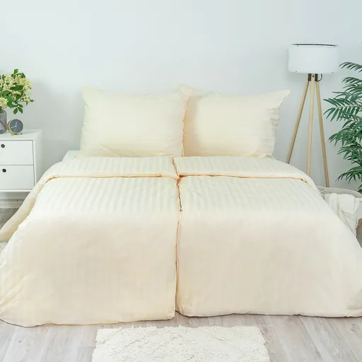
Stanex Povlečení atlas grádl smetanová, 140 x 220 cm, 70 x 90 cm
Povlečení z materiálu atlas grádl nabízí hebkost a pohodlí. Sada obsahuje povlak na přikrývku 140x220 cm a povlak na polštář 70x90 cm v smetanovém odstínu. Je vyrobeno z kvalitní bavlny a vyznačuje se elegantním designem s proužky.
- Vyrobeno ze 100% kvalitní bavlny pro maximální pohodlí
- Elegantní design s 2,5 cm proužky a noblesním smetanovým odstínem
- Snadná údržba - doporučeno prát naruby bez agresivní chemie
Objev podobné jako Stanex Povlečení atlas grádl smetanová, 140 x 220 cm, 70 x 90 cm

Stanex Povlečení atlas grádl starorůžová, 140 x 220 cm, 70 x 90 cm
Povlečení z materiálu atlas grádl nabízí hebkost a pohodlí díky 100% bavlně. Design s 2,5 cm proužky a starorůžovým odstínem přináší do ložnice noblesní vzhled. Souprava obsahuje povlak na přikrývku 140x220 cm a povlak na polštář 70x90 cm.
- Vyrobeno ze 100% kvalitní bavlny pro maximální pohodlí
- Elegantní starorůžový odstín a struktura proužků
- Snadná údržba - doporučeno prát naruby bez agresivní chemie
- Kompletní souprava obsahuje povlak na přikrývku i polštář
Objev podobné jako Stanex Povlečení atlas grádl starorůžová, 140 x 220 cm, 70 x 90 cm
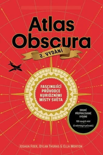
Atlas Obscura - Joshua Foer, kolektiv autorů
Atlas Obscura je průvodce představující přes 700 nejpodivuhodnějších a nejméně známých míst na planetě. Zahrnuje přírodní zázraky, bizarní lidské výtvory a tajemné lokality. Kniha slouží jako inspirace pro cestovatele hledající neobvyklé zážitky.
- Obsahuje více než 700 unikátních a kuriózních míst z celého světa.
- Inspiruje k objevování neznámých a nevyšlapaných cest.
- Bohatě ilustrovaný průvodce pro milovníky dobrodružství a záhad.
Objev podobné jako Atlas Obscura - Joshua Foer, kolektiv autorů
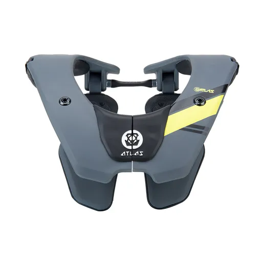
Dětský chránič krční páteře ATLAS Tyke Grey
Dětský chránič krční páteře ATLAS Tyke Grey je určen pro motokros, BMX, čtyřkolky a horská kola. Konstrukce Split-Flex Frame a systém ERS zajišťují pohyblivost a možnost rychlého odložení. Chránič zabraňuje hyperflexi, hyperextenzi a axiálnímu zatížení páteře.
- Patentovaná flexibilní konstrukce Split-Flex Frame pro maximální pohyblivost
- Systém ERS umožňující rychlé odložení chrániče při nehodě
- Široká kontaktní zóna a odpružení hrudní části pro vyšší bezpečnost
- Minimalistický design s nízkou hmotností (460 g) pro pohodlí dítěte
Objev podobné jako Dětský chránič krční páteře ATLAS Tyke Grey

Stanex Povlečení atlas grádl smetanová, 140 x 200 cm, 70 x 90 cm
Povlečení z atlas grádlu je vyrobeno ze 100% bavlny a nabízí pohodlí s hebkou strukturou. Smetanový odstín a proužkový design přináší do ložnice eleganci. Souprava obsahuje povlak na polštář 70x90 cm a povlak na přikrývku 140x200 cm.
- Vyrobeno z 100% kvalitní bavlny pro mimořádnou hebkost
- Elegantní struktura 2,5 cm proužků podtrhne design
- Smetanový odstín dodá ložnici noblesní vzhled
- Snadná údržba - doporučeno prát naruby bez bělidel
Objev podobné jako Stanex Povlečení atlas grádl smetanová, 140 x 200 cm, 70 x 90 cm

Stanex Povlečení atlas grádl světle šedá, 140 x 220 cm, 70 x 90 cm
Povlečení Stanex z atlas grádlu je vyrobeno z 100% bavlny a nabízí pohodlí s elegantním designem proužků. Světle šedý odstín dodá ložnici noblesní vzhled. Sada obsahuje povlak na přikrývku 140 x 220 cm a povlak na polštář 70 x 90 cm.
- Vyrobeno ze 100% kvalitní bavlny pro mimořádnou hebkost.
- Elegantní design s 2,5 cm proužky a světle šedým odstínem.
- Snadná údržba – perte naruby bez agresivní chemie.
- Kompletní sada obsahuje povlak na přikrývku i polštář.
Objev podobné jako Stanex Povlečení atlas grádl světle šedá, 140 x 220 cm, 70 x 90 cm
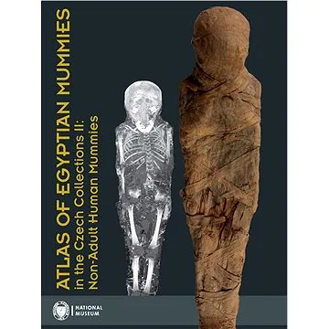
Atlas of Egyptian Mummies in the Czech Collections II: Non-Adult Human Mummies (978-80-7036-750-6)
Druhý díl série Atlas egyptských mumií v českých sbírkách se specializuje na mumie a pohřební vybavení dětí a dospívajících do 15 let. Obsahuje podrobný katalog dvou kompletních mumií, dvanácti izolovaných částí a šesti pohřebních schránek. Publikace přináší informace o zdravotním stavu, nemocech a pohřebních praktikách dětí ve starověkém Egyptě.
- Druhý díl odborné série o egyptských mumiích
- Zaměření na mumie dětí a dospívajících do 15 let
- Podrobný katalog s proveniencí a zdravotními analýzami
- Vědecky hodnotný materiál z Národního muzea v Praze
Objev podobné jako Atlas of Egyptian Mummies in the Czech Collections II: Non-Adult Human Mummies (978-80-7036-750-6)
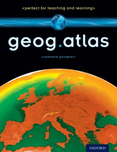
geog.atlas - Gallagher RoseMarie
geog.atlas is an engaging atlas of accessible maps and supporting information. It features unique coverage of places likely to appear in the news, such as the Middle East, Afghanistan, and the Falklands. Special maps look at themes like global warming, desertification, and how people spread around the world. Stunning satellite images are placed alongside physical geography maps to aid understanding. ''Did you know?'' and ''What if?'' circles provide interesting extra information and engaging facts.Full of clearly-labelled maps, straightforward explanations, and advice on how to ''read'' maps and understand what they show, it will help improve students'' basic locational knowledge, enhance their understanding, and build their confidence.geog.atlas supports teachers whether they''re using geog.123 or an alternative course at KS3.
Objev podobné jako geog.atlas - Gallagher RoseMarie
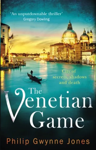
The Venetian Game - Philip Gwynne Jones
''An unputdownable thriller'' Gregory Dowling''It is no surprise to find that Philip Gwynne Jones lives in Venice... art and architecture interweave into a story that builds to an almost surreal climax'' Daily Mail*****A game of cross and double-cross in Venice, one of the most beautiful cities on earth.From his office on the Street of the Assassins, Nathan Sutherland enjoys a steady but unexciting life translating Italian DIY manuals. All this changes dramatically when he is offered a large sum of money to look after a small package containing an extremely valuable antique prayer book illustrated by a Venetian master. But is it a stolen masterpiece - or a brilliant fake?Unknown to Nathan, from a vast mansion on the Grand Canal twin brothers Domenico and Arcangelo Moro, motivated by nothing more than mutual hatred, have been playing out a complex game of art theft for twenty years. And now Nathan finds himself unwittingly drawn into their deadly business . . .*****Praise for Philip Gwynne Jones''I devoured all Philip''s novels and felt transported to Venice with a new intimacy'' Val McDermid''Superb - always gripping, beautifully constructed and vivid'' Stephen Glover''Sinister and shimmering, The Venetian Game is as haunting and darkly elegant as ... Unknown localization key: "more"
Objev podobné jako The Venetian Game - Philip Gwynne Jones
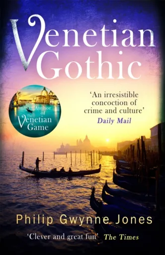
Venetian Gothic - Philip Gwynne Jones
''A riveting story of deception and corruption'' Daily Mail''A must for all Italy lovers'' David HewsonEven the most beautiful city on earth has a dark side . . .It is November 2nd, 2017. All Souls Day. On the Day of the Dead, the citizens of Venice make their way to the cemetery island of San Michele to pay their respects to the departed. When an empty coffin is unearthed in the English section of the graveyard, a day of quiet reflection for Nathan Sutherland becomes a journey into the dark past of a noble Venetian family.A British journalist, investigating the events of forty years previously, disappears. A young tourist - with an unhealthy interest in Venice''s abandoned islands - is found drowned in the icy lagoon.A terrible secret is about to be brought to light, and a deadly reckoning awaits on Venice''s Isle of the Dead.Praise for Philip Gwynne Jones''I devoured all Philip''s novels and felt transported to Venice with a new intimacy'' Val McDermid''An unputdownable thriller'' Gregory Dowling''Pure pleasure'' Literary Review''Clever and great fun'' The Times''An irresistible concoction of crime and culture''Daily Mail''Superb - always gripping, beautifully constructed and vivid'' Stephen Glover''Sinister and shimmering . . . as haunting ... Unknown localization key: "more"
Objev podobné jako Venetian Gothic - Philip Gwynne Jones
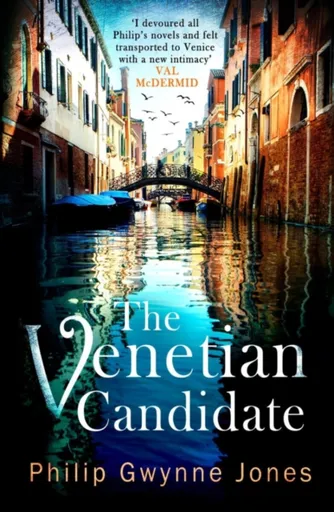
The Venetian Candidate - Philip Gwynne Jones
'An unputdownable thriller' Gregory Dowling 'It is no surprise to find that Philip Gwynne Jones lives in Venice... art and architecture interweave into a story that builds to an almost surreal climax' Daily Mail 'Gwynne Jones's talent for evoking place and atmosphere is clear as ever' Literary Review 'An impressive, tersely-written account linking old crimes to the political contention in the country at present... Recommended' The Critic _______________To tell the truth is a revolutionary act. Battered by floods and crushed by overtourism, the city of Venice faces an uncertain future. The election of a new Mayor, therefore, has never felt more important. As the candidates jostle for position and alliances are made and promises broken, Andrea Mazzon, a controversial writer and historian, emerges as a strong candidate. Nathan Sutherland, meanwhile, has more important things on his mind as he investigates the case of an elderly British academic who has disappeared while researching the fate of his grandfather during the Great War. The trail leads to a remote Common-wealth war cemetery where, under the ice and snow, Nathan makes a discovery that links the terrible events of a century ago with the electoral campaign in La Serenissima. A campaign that might ... Unknown localization key: "more"
Objev podobné jako The Venetian Candidate - Philip Gwynne Jones
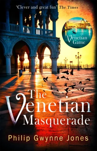
The Venetian Masquerade - Philip Gwynne Jones
''An irresistible concoction of crime and culture'' Daily MailA game of blackmail and betrayal is played among the backstreets and canals of Venice . . .Carnevale is in full swing, the streets and waterways of Venice are crowded with masked revellers and Nathan Sutherland''s birthday is about to be ruined.A night at the opera at La Fenice is always a memorable experience - and this time it will be so for all the wrong reasons as the curtain call is interrupted by a fatal stabbing. But why is the dead man carrying one of Nathan''s business cards in his wallet?The mystery of the murdered stranger takes Nathan on the trail of a lost opera by Monteverdi. But what begins as a harmless treasure hunt leads to ruthless criminals asking the highest of prices for the lost score... and then a second body is found in the sanctuary of Venice''s English church.The quest for the lost manuscript will bring Nathan back to the stage of La Fenice, where a final confrontation has deadly consequences...Praise for Philip Gwynne Jones''I devoured all Philip''s novels and felt transported to Venice with a new intimacy'' Val McDermid''Gwynne Jones'' entertaining take on his beloved Venice is ... Unknown localization key: "more"
Objev podobné jako The Venetian Masquerade - Philip Gwynne Jones

Stanex Povlečení atlas grádl starorůžová, 140 x 200 cm, 70 x 90 cm
Povlečení z atlas grádlu je vyrobeno ze 100% bavlny a nabízí pohodlí a hebkost. Souprava obsahuje povlak na přikrývku 140 x 200 cm a povlak na polštář 70 x 90 cm. Elegantní design s proužkovou strukturou a starorůžovým odstínem dodává ložnici noblesní vzhled.
- Vyrobeno ze 100% kvalitní bavlny pro mimořádnou hebkost.
- Elegantní design s 2,5 cm proužkovou strukturou.
- Starorůžový odstín dodává ložnici noblesní vzhled.
- Snadná údržba - doporučeno prát naruby bez bělidel.
Objev podobné jako Stanex Povlečení atlas grádl starorůžová, 140 x 200 cm, 70 x 90 cm
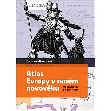
Atlas Evropy v raném novověku: Od renesance po osvícenství (978-80-7508-836-9)
Kniha - autor Pierre-Yves Beaurepaire, 96 stran, česky, polotuhá flexo Atlas podává ucelený obraz převratných změn, kterými evropské státy procházely od 16. do 18. století. Zachycuje četné válečné konflikty, složité mezinárodní vztahy, ale i ekonomický vývoj a proměny v oblasti vědy a umění. Podrobně popisuje, jak Evropa vstoupila do epochy moderních dějin. Atlas Evropy v raném novověku čtenáři nabízí pohled na dynamický vývoj Evropy během více než tří set let, kdy období míru a pořádku střídaly války a nestabilita a kdy se země uzavíraly do sebe, nebo se naopak otevíraly světu. V knize najdete například odpovědi na otázky: Jak renesanční Evropu propojily knihtisk a umění či boj proti Turkům? Jak Evropu rozdělily náboženské spory v období reformace? Kterými válečnými střety Evropa procházela v éře baroka? Jak osvícenská Evropa nezadržitelně směřovala k revoluci? Kniha obsahuje hlavní kapitoly: Úvod Renesanční Evropa – rozvoj...
Objev podobné jako Atlas Evropy v raném novověku: Od renesance po osvícenství (978-80-7508-836-9)
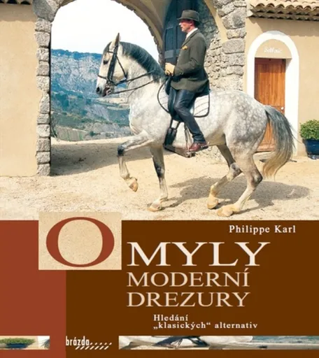
Omyly moderní drezury - Karl Philip
Kritická a burcující kniha o sportovní drezuře a o tom, co se z ní dnes mnohde stalo. Autor na základě psychických, anatomických a fyziologických předpokladů koně analyzuje základní pravidla moderní drezury, jak je popisují směrnice německé jezdecké federace (FN). Srovnáváním s názory největších mistrů jezdecké literatury od Guérinieriho až po Bauchera se mu daří odkrývat dogmata a omyly moderní drezury a poukazovat na způsoby řešení, které by ji vyvedly ze slepé uličky, v níž se dnes nachází.
Objev podobné jako Omyly moderní drezury - Karl Philip
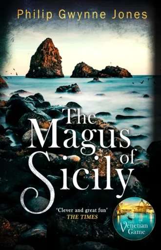
The Magus of Sicily - Philip Gwynne Jones
''If this book is not popular with fans of The White Lotus, something is definitely awry . . . [a] sumptuously set mystery'' Daily Mirror''Invokes Italy''s most exquisite island as a setting for myth and murder . . . Truly evocative'' Financial Times''Tension that keeps us rooted to the page'' Daily Mail------------An island of myth, legend . . . and murder?As the summer sun beats down on the ancient town of Acitrezza, a folk festival plays out in the picturesque harbour. Music, laughter and the aroma of local delicacies fill the air, and a traditional pantomime draws a crowd.For rookie journalist Nedda Leonardi, it''s just another day''s reporting in a calendar of unremarkable events. Until that is, the performers dive in the sparkling Ionian Sea for their finale... and emerge with a corpse. Could this be Nedda''s big break?After one trick too many, Calogero Maugeri, self-styled Magus and con artist, is a wanted man. But his attempts to clean up his act and keep a low profile are thwarted when it''s revealed he has a suspicious connection to the dead man pulled from the sea.A young reporter keen for a scoop and a reformed swindler desperate to clear his name... ... Unknown localization key: "more"
Objev podobné jako The Magus of Sicily - Philip Gwynne Jones
The Atlas Maneuver - Steve Berry
Román představuje nové dobrodružství Cottona Malonea, který se zaplete do pátrání po legendárním japonském válečném pokladu zvaném Yamashitovo zlato. Příběh propojuje historické události z konce druhé světové války se současnou hrozbou zneužití kryptoměn k narušení globálního finančního systému. Děj zavede čtenáře do Švýcarska, Lucemburska a marockých hor v honbě za odhalením konspirace známé jako Atlasovo manévr.
- Nejnovější díl oblíbené série Cotton Malone
- Napínavý příběh kombinující historická fakta a fikci
- Rychlý spád děje s mezinárodním přesahem
- Aktuální téma kryptoměn v thrillerovém kontextu
Objev podobné jako The Atlas Maneuver - Steve Berry
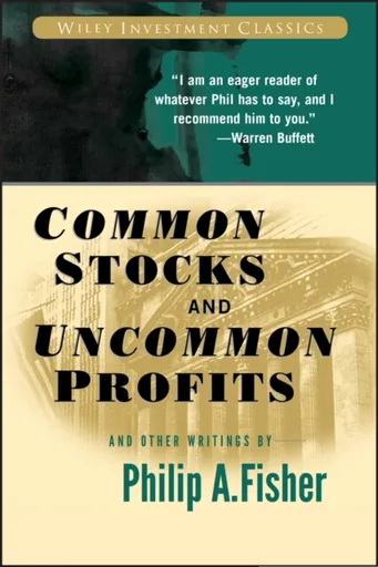
Common Stocks and Uncommon Profits and Other Writings - Philip A. Fisher
Regarded as one of the pioneers of modern investment theory, Philip Fisher's principles are studied and used by numerous contemporary finance professionals, including Warren Buffett. Common Stocks and Uncommon Profits and Other Writingsis invaluable reading and has been since it was first published in 1958.
Objev podobné jako Common Stocks and Uncommon Profits and Other Writings - Philip A. Fisher
Golden Compass Graphic Novel, Complete Edition - Philip Pullman
A single-volume compilation of the graphic novel adaptations of the first book in Philip Pullman''s modern classic trilogy collects the full story of Lyra''s early days at Oxford, her journey to the far north to rescue the kidnapped children, her hot-air balloon escape and her role in Asriel''s plot to build a bridge to another world. Simultaneous and eBook.
Objev podobné jako Golden Compass Graphic Novel, Complete Edition - Philip Pullman
KIEPE Nůžky na vlasy Sada School 5.5“ + Efilační nůžky 5.5“ (8008981910617)
Sada KIEPE obsahuje profesionální kadeřnické nůžky o délce 14 cm a efilační nůžky se 32 zuby, vhodné pro začátečníky a výuku. Oba kusy jsou vyrobeny z tvrzené nerezové oceli a mají semi-offset typ držení. Součástí balení je černé koženkové pouzdro s logem.
- Kompletní sada pro začínající kadeřníky obsahující střihací i efilační nůžky
- Vyrobeno z kvalitní tvrzené nerezové oceli pro dlouhou životnost
- Pohodlné semi-offset držení snižující únavu při práci
- Elegantní koženkové pouzdro s patentkou pro bezpečné uložení a přenášení
Objev podobné jako KIEPE Nůžky na vlasy Sada School 5.5“ + Efilační nůžky 5.5“ (8008981910617)
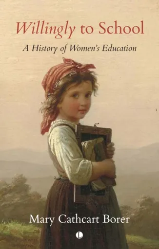
Willingly to School - Mary Cathcart Borer
The denial of equal educational opportunities to women is arguably one of the great injustices in British history. In Willingly to School, Mary Cathcart Borer charts the gradual reversal of this inequality, and the revolutionary effect it has had on social structures, from the Anglo-Saxons to the twentieth century. Always mindful of the historical context of each period, Borer explores the significant early role of the church, the opportunities afforded to royal and noble girls, the origins of the various forms of privately and charitably funded school, and the emergence of the modern school system. Along the way, particular significant institutions and individuals such as Christ''s Hospital, Cheltenham Ladies College, the Brontë sisters and Fanny Burney are examined in depth.Writing in 1975, Borer described the mid-twentieth century as having ''seen the culmination of women''s demands for full equality in society''. While the intervening years have shown that there is still much work to be done in the pursuit of equality, Borer''s analysis of the progress that has been made in women''s education remains as pertinent as ever.
Objev podobné jako Willingly to School - Mary Cathcart Borer
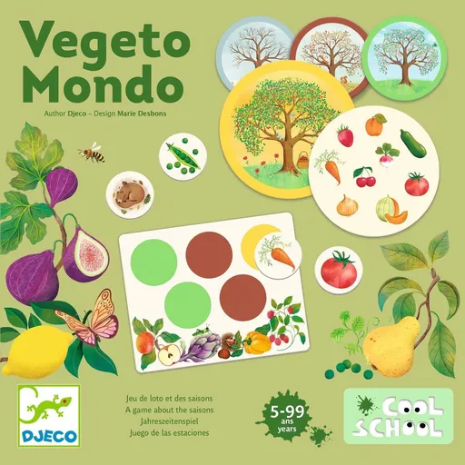
Loto hra Cool School Vegeto Mondo
Didaktická loto hra zaměřená na flóru planety učí děti přiřazovat ovoce a zeleninu k ročním obdobím. Sada obsahuje 6 bingo desek, 4 sezónní karty, 36 žetonů zvířat a látkovou tašku. Hra je vhodná pro děti od 5 let, trvá přibližně 15 minut a je vyrobena z certifikovaných materiálů.
- Rozvíjí znalosti o ročních obdobích a plodech země
- Citlivé ilustrace flóry podporují vztah k přírodě
- Kvalitní materiál s ekologickou certifikací FSC
- Vhodné pro samostatnou i skupinovou hru (1-6 hráčů)
Objev podobné jako Loto hra Cool School Vegeto Mondo
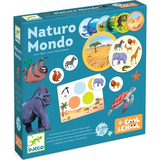
Loto hra Cool School Naturo Mondo
Loto hra Cool School Naturo Mondo je didaktická hra zaměřená na faunu planety. Děti se pomocí herních desek, karet prostředí a žetonů seznamují s přirozeným prostředím zvířat v různých ekosystémech. Hra je určena pro 1-6 hráčů od 5 let a je vyrobena z certifikovaného papíru a lepenky.
- Seznamuje děti s faunou a ekosystémy celé planety
- Výuková hra s citlivými ilustracemi zvířat
- Vyrobeno z certifikovaného materiálu FSC
- Vhodné pro 1-6 hráčů od 5 let, hra trvá cca 15 minut
Objev podobné jako Loto hra Cool School Naturo Mondo
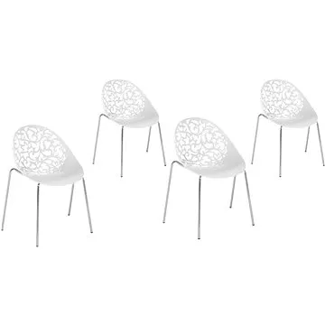
Moderní bílá sada jídelních židlí MUMFORD, 155321 (beliani_155321)
Jedná se o sadu čtyř moderních jídelních židlí v bílé barvě. Konstrukce je vyrobena z kovu, sedák z plastu s výškou 42 cm. Židle mají rozměry 80 × 62 × 43 cm a nosnost 100 kg.
- Moderní design vhodný do současných interiérů
- Robustní konstrukce z kovu s nosností 100 kg
- Praktická sada 4 židlí v jednom balení
- Snadná údržba díky plastovému sedáku
Objev podobné jako Moderní bílá sada jídelních židlí MUMFORD, 155321 (beliani_155321)
OMNIRES MODERN PROJECT držák ručníků, 60 cm zlatá /GL/ MP60216GL
Držák ručníků OMNIRES MODERN PROJECT má šířku 60 cm a je vyroben z mosazi. Design vychází z kruhového tvaru a kombinuje minimalistickou formu s moderním charakterem. Povrch má zlatý lesklý odstín.
- Minimalistický a nadčasový design s kruhovým tvarem
- Vyrobeno z kvalitní mosazi pro dlouhou životnost
- Elegantní zlatý lesklý povrch
- Kompaktní rozměry (60 cm šířka, 4 cm výška)
Objev podobné jako OMNIRES MODERN PROJECT držák ručníků, 60 cm zlatá /GL/ MP60216GL
Matex Saténové povlečení Modern, 140 x 200 cm, 70 x 90 cm
Povlečení je vyrobeno z bavlněného saténu, který kombinuje eleganci, jemnost a trvanlivost. Nabízí pohodlí díky prodyšnosti a schopnosti přizpůsobit se teplotě, s jednoduchou údržbou bez nutnosti žehlení. Souprava obsahuje povlak na polštář 70 x 90 cm a povlak na přikrývku 140 x 200 cm.
- Vyrobeno z prvotřídního bavlněného saténu s hedvábným leskem pro luxusní vzhled.
- Prodyšný materiál přizpůsobivý teplotě: v létě chladí, v zimě hřeje.
- Dlouhá životnost díky kvalitnímu zpracování, zachovává tvar a barvy i po častém praní.
- Snadná údržba – odolné proti mačkání, nevyžaduje speciální péči nebo žehlení.
Objev podobné jako Matex Saténové povlečení Modern, 140 x 200 cm, 70 x 90 cm